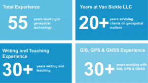
With many years of experience, I’ve advised global companies (Anadarko, IHS Energy, Microsoft, Jeppesen, Maxar, and many more) in geospatial matters. I’ve created and led departments, managed creation of new programs, and developed systems used around the globe. I earned my Ph.D. in geospatial engineering from the University of Colorado, and am an Assistant Teaching Professor at Penn State University and Lecturer at the University of Colorado (Denver).

Academic and Professional Qualifications

Nebraska_Cornhuskers_logo.svgWayne_w  cuboulder-large

Bachelors degree with honors, University of Nebraska (Lincoln)

Masters degree work, Wayne State University (Detroit)

Master of Engineering, University of Colorado (Denver)

PhD. Geospatial Engineering, University of Colorado (Denver)

Registered Professional Land Surveyor: Colorado, California, Oregon, North Dakota, Pennsylvania, West Virginia and Texas


Work Experience

I am an independent contractor and have advised Anadarko, IHS Energy, Chesapeake, Microsoft, Intermap, Jeppesen, Geoeye, Hess, Laredo, Enserca, Maxar and others in geospatial matters. During this time I have managed the creation of the worldwide T&E sites for two major earth observation satellites which were used for frequent accuracy assessments. I have conducted a spatial accuracy comparison study for Maxar in Durban, South Africa, Seoul, South Korea and Rio De Janeiro, Brazil. I conducted training at the NAVCEN for the USCG and NSA personnel at Leidos. I have provided technical assistance in the reconstruction of the geodetic network of Nigeria. I have managed the gravity/magnetic and hyperspectral/multispectral analysis of Borzon VII a concession block in the South Gobi in Mongolia.

See Entire Work History >>

Books

GPS for Land Surveyors: 4th edition: CRC

Surveying Solved Problems: 4th edition: Professional Publications

Basic GIS Coordinates: 3rd edition: Taylor and Francis of London and CRC

http://www.amazon.com/Jan-Van-Sickle/e/B001ITTL8O


Articles

Spar Point Group Blog: From Scratch: 2015. http://www.sparpointgroup.com/jan-van-sickle

Schuckman, K. and J. Van Sickle (2010) Education in Surveying: The Geospatial Technology Competency Model. Professional Surveyor, Volume 30 Issue 8 August 2010.

Johnson, C., M. Denny and J. Van Sickle (2009) Land Base Accuracy and Land Surveyors, ACSM Bulletin 238, April 2009.

Mangold, R. and J. Van Sickle (2008) All LiDAR Data is Not Created Equal: A discussion about the LiDAR production process. Point Of Beginning Volume 33, Number 5, February 2008.

Van Sickle, J. (1982) Vertical Triangulation and the Magnesium Bullet. Professional Surveyor, Volume 2 Number 3 May/June 1982.

Teaching

PENNSYLVANIA STATE UNIVERSITY
GNSS and GPS Modernization – Senior Lecturer (2005-PRESENT)

UNIVERSITY OF COLORADO
GNSS and GPS – Lecturer

DENVER INSTITUTE OF TECHNOLOGY
Advanced Program Instructor (1986-1989)
Public Lands
Land Boundary Law 1&2
Surveying Astronomy
Surveying Mathematics
Advanced Mathematics
Land Survey Descriptions
Geodesy 1&2

ONLINE COURSES
[PDHOnline: www.pdhonline.com (5941 students 2002-2020)]
GPS Surveying
Land Boundary I
Land Boundary II
Coordinates

Patents

Van Sickle, N., J. Van Sickle and V. Van Sickle (1981) Vertical Projection Triangulation Projectile. U.S. Patent No. 4,301,732, November 24, 1981.

Van Sickle Open Ditch Pipeline As-Built Process US 9,230,453 B2


Professional Memberships

Former Vice –Chairman of GIS in the Rockies

Former Regional Board member ACSM and ASPRS

Member of The Association of Petroleum Surveying & Geomatics – APSG

Former Chairman of American Petroleum Surveyors Group US West Chapter

Member of ASPRS

Scientific and Professional Services

Member of Geospatial Thought Leadership Council, QinetiQ; Arlington, VA

Member of Geospatial Technology Competency Modeling (GTCM) Panel, US Department of Labor and the Geotech Center; Scottsdale, AZ

Member of Remote Sensing DACUM Panel, US Department of       Labor and the Geotech Center; Denver, CO

Vice Chairman of GIS in the Rockies; Denver, CO

Geospatial Curriculum Consultant, Front Range Community College; Longmont, CO

Member of Geodesy and GIS Panel, ESRI; San Diego, CA 2009

Seminars and Proceedings

(2021) LiDAR, IMU and GNSS in Mobile Mapping, Accuracy, Error Analysis and Statistics; Coordinates & Geodesy, Best Practices of GNSS Today, 7 Western States Regional Conference, March 28

(2021) GPS Modernization and GNSS; LiDAR, IMU and GNSS in Mobile Mapping, Rocky Mountain Surveyors Summit, February 23

(2021) Accuracy, Error Analysis and Statistics; Coordinates & Geodesy: Rocky Mountain Surveyors Summit, February 22

(2021) GPS Modernization and GNSS; Best Practices of GNSS Today: Utah Council of Land Surveyors Conference, February 18

(2021) Boundary Law and Legal Terms; Professional Land Surveyors of Colorado Refresher Course: February 3

(2021) GIS, State Plane Coordinates, Geodesy and Photogrammetry: Professional Land Surveyors of Colorado Refresher Course: January 27

Van Sickle J. (2020) Boundary Law, Legal Terms and Definitions: Professional Land Surveyors of Colorado Refresher Course: February 5

Van Sickle J. (2020) GIS, State Plane Coordinates, Geodesy and Photogrammetry: Professional Land Surveyors of Colorado Refresher Course: January 29

Van Sickle J. (2020) GPS Modernization and GNSS & Best Practices of GNSS Today: 59th Annual Fresno State Geomatics Engineering Conference, January 25

Van Sickle J. (2020) Coordinates & Geodesy: South Dakota Society of Professional Land Surveyors, January 10

Van Sickle J. (2020) Best Practices of GNSS Today: South Dakota Society of Professional Land Surveyors, January 9

Van Sickle, J. (2019) Positioning Navigation and Timing. Leidos. March 28-29

Van Sickle, J. (2019) GIS, State Plane Coordinates, Geodesy, Photogrammetry Refresher Course. Professional Land Surveyors of Colorado,  January 30

See More Seminars >>